

Sensing the city: big data for environmental analysis
Many new data sources are available in cities, generating large amounts of data that create an unprecedented opportunity for urban studies. There are three types of data gathering: opportunistic, user generated and purposely sensed.
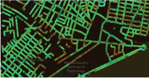
Opportunistic sensors are those already deployed for specific purposes, but that generate data than can help us to understand other aspects of the city. Cell phone data is an example: used for communication, mapping cell phone calls enables us to understand mobility patterns with fine temporal and spatial granularity.
User generated data are purposely generated and made available by citizens, and can include citizens-science initiatives, such as air quality monitoring as well as
self-tracking devices (such as walking and biking apps), whose aggregated data can not only inform but also engage citizens in decision-making processes.
Finally, we propose to design sensors for specific uses which can be deployed in specific situations, such as thermal cameras on bus fleet to detect building heat loss or a network of automated samplers to monitor wastewater in the sewage network. We propose the combination of such sensing efforts for environmental analysis – gaining better insights into the urban ecosystem and its transformation through design.
Questions that could be addressed include
- How to assess overall urban sustainability?
- How to monitor pollutants in the atmosphere?
- How to integrate citizens in this process?
- How to simplify the decision making processes for urban transformation?
- What are the institutional aspects related the use of data?